VO2 max tests are pretty cool - if you enjoy high intensity exercise. You don't need to have one done to evaluate performance, but it does act as a good reference tool for training guidelines.
Monday, September 27, 2010
VO2 Max Test - Useful for training but does not predict performance
I recently did another VO2 max test in USC's Kinesiology lab to help some new instructors get acquainted with setup and and watch how a test goes.
VO2 max tests are pretty cool - if you enjoy high intensity exercise. You don't need to have one done to evaluate performance, but it does act as a good reference tool for training guidelines.
Here's the blurb I wrote in the description:
VO2 max tests are pretty cool - if you enjoy high intensity exercise. You don't need to have one done to evaluate performance, but it does act as a good reference tool for training guidelines.

Sunday, August 29, 2010
Why moving a little too fast can cost you a lot, especially at altitude
Ever head out trying to follow someone's blistering pace, only to finally slow down and feel depleted? When that happens, you actually can't just slow down a little bit to "make up" for speeding up before. No, basically you've screwed yourself for the rest of the day. Why?
When you hike (or run, bike, etc...), you are using multiple energy pathways. The rate of energy production from each of these pathways is different.
Reference

For the sake of simplicity, we are only going to talk about the two systems that use glycogen (stored sugar). Anaerobic glycolysis can produce ATP (energy) at a faster rate than aerobic glycolysis can. The faster you are moving and harder you are working, the more energy you are going to get anaerobically. Ok sounds great!
But as you would guess, there's a cost to that. The cost is how much glycogen is used.
When you hike (or run, bike, etc...), you are using multiple energy pathways. The rate of energy production from each of these pathways is different.
Reference

For the sake of simplicity, we are only going to talk about the two systems that use glycogen (stored sugar). Anaerobic glycolysis can produce ATP (energy) at a faster rate than aerobic glycolysis can. The faster you are moving and harder you are working, the more energy you are going to get anaerobically. Ok sounds great!
But as you would guess, there's a cost to that. The cost is how much glycogen is used.
Thursday, July 1, 2010
Are Porter's More Efficient?
Link to Abstract, Embedded article below
I came across an interesting paper that was looking how and why are Himalayan porters able to move much faster than their Caucasian counterparts...outside of their superior chronic acclimation to high altitudes. Basically, they are more efficient, but why?
I came across an interesting paper that was looking how and why are Himalayan porters able to move much faster than their Caucasian counterparts...outside of their superior chronic acclimation to high altitudes. Basically, they are more efficient, but why?
Wednesday, June 23, 2010
Editing GPX Files
Many GPS devices come with their own mapping / editing software that may or may not be sufficient for your own analysis. Personally, I use Matlab for much of my processing b/c I have a lot of control, but you'll also have to do a bit of programming.
First, if you want to convert your file from your specific file type to .gpx (or vice versa), I suggest using GPS Babel.
For some editing / analysis, you can use Excel. Open Excel then open the .gpx file. I would open it as "read only" or "xml-source" which seems to disable the macros. From here, you can plot / analysis the columns of data, including latitude, longitude, altitude, and time. However I don't think you'll be able to save it back as a .gpx file.
The easiest way is to download the free GPX Editor. Open up a .gpx file inside, and select the specific track segment you wish to edit. While I have not checked out all the options, I know you can double click on a row and edit the information inside. Make sure you hit the "check" box or it won't save the change.
First, if you want to convert your file from your specific file type to .gpx (or vice versa), I suggest using GPS Babel.
For some editing / analysis, you can use Excel. Open Excel then open the .gpx file. I would open it as "read only" or "xml-source" which seems to disable the macros. From here, you can plot / analysis the columns of data, including latitude, longitude, altitude, and time. However I don't think you'll be able to save it back as a .gpx file.
The easiest way is to download the free GPX Editor. Open up a .gpx file inside, and select the specific track segment you wish to edit. While I have not checked out all the options, I know you can double click on a row and edit the information inside. Make sure you hit the "check" box or it won't save the change.
Tuesday, June 22, 2010
Google Earth Mapping Discussion Update
Earlier this year I outlined a way to overlay topographic maps in Google Earth, and subsequently get out path information to make maps and upload to your GPS device. The main downside with this method was that Google Earth did not provide elevation data when you created a path, so you would also have to use something like GPS Visualizer to get that information.
I was tipped off by Modern Hiker that the new version of Google Earth (5.2) is out and now it provides the elevation from its digital elevation model (DEM). Now when you create a path, you can right click on it's name in the sidebar and go to "Show Elevation Profile." Something like below should open up:
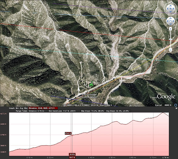
If you try to save the .kml file, the elevation data won't be included, so use of the elevation is inclusive only to viewing in Google Earth. Still, this addition combined with the topo overlay offers excellent options for route planning.
I was tipped off by Modern Hiker that the new version of Google Earth (5.2) is out and now it provides the elevation from its digital elevation model (DEM). Now when you create a path, you can right click on it's name in the sidebar and go to "Show Elevation Profile." Something like below should open up:
If you try to save the .kml file, the elevation data won't be included, so use of the elevation is inclusive only to viewing in Google Earth. Still, this addition combined with the topo overlay offers excellent options for route planning.
Thursday, May 13, 2010
Some Thoughts on Knee Loading Mechanics
When hiking and doing other physical activities, our musculoskeletal system undergoes increased loading - in the muscles, tendons, cartilage, etc... Understanding how different postures / mechanics change loading may be beneficial in terms of hiking - how do you walk downhill to redistribute load in an ideal way for you?
For instance, many people end up with some knee problems from hiking downhill. There are several specific problems that could arise in the knee that are affected by different loadings, but an important one is the moment / torque --> muscular demand of the muscles crossing the knee joint. To illustrate how the magnitudes of these loads could change, we'll use a simple example of a weighted squat.

Here are three different positions where one could hold a barbell while performing a squat. A fundamental requirement of whole body movement is the balance constraint. To not lose your balance, you must keep your center of mass (CM) in a horizontal position in which you can maintain. Your CM accounts for the weighted average position of all your body segments (and the weight and position of the barbell, in this case). To remain stable, the force acting on your feet must be vertical and go directly through the CM (dashed lines in figure above).
If the force acts vertically but is in front of your CM, you will start to tip backwards. This is because you are generating a moment about your CM. Same effect if the force is behind the CM. And the CM must be aligned horizontally to be withing the horizontal range of your feet, or else you won't be able to keep the force aligned!
Given these requirements, if one changes where the barbell is positioned, this will change the overall CM location. In order to ensure the CM sits at the middle of the feet, one must change the kinematics of their segment / joint orientations, as seen in the figure above.
The consequence of this can also be seen in the figure - look at how the distance between the dashed line and middle of the knee decreases from left to right in the figures. The moment arm about the knee joint is decreasing. Given a force "F" that includes the barbell weight + bodyweight, and a moment arm "x", the moment / torque that is needed to be generated about the knee is T = F * x. As x decreases, the moment needed will decrease.
What does this imply? Well the smaller the moment demand, the less force the quadriceps muscles will have to generate. Less force will mean less contact force between the femur (thigh), patella (knee cap), and tibia (shank). This may be good, depending on your current state and injury history. On the other hand, the decrease in moment about the knee means an increase in moment about the hip.
Now there is a lot more complexity than this, but the take home message is that you can redistribute muscle and joint loading by orientation of your body segments, whether in squatting or hiking or anything else. Changes may be beneficial if you are suffering from musculoskeletal problems.
Tuesday, May 4, 2010
Salt Stains and Tips on Electrolyte Replenishment
Here's a decent article on electrolyte loss from sweating and replacement. Of course, this can be extremely important on strenuous hikes on hot days. Especially because you'll be a little more stranded in the wilderness than in a race!
Subscribe to:
Posts (Atom)