Many GPS devices come with their own mapping / editing software that may or may not be sufficient for your own analysis. Personally, I use Matlab for much of my processing b/c I have a lot of control, but you'll also have to do a bit of programming.
First, if you want to convert your file from your specific file type to .gpx (or vice versa), I suggest using GPS Babel.
For some editing / analysis, you can use Excel. Open Excel then open the .gpx file. I would open it as "read only" or "xml-source" which seems to disable the macros. From here, you can plot / analysis the columns of data, including latitude, longitude, altitude, and time. However I don't think you'll be able to save it back as a .gpx file.
The easiest way is to download the free GPX Editor. Open up a .gpx file inside, and select the specific track segment you wish to edit. While I have not checked out all the options, I know you can double click on a row and edit the information inside. Make sure you hit the "check" box or it won't save the change.
Wednesday, June 23, 2010
Tuesday, June 22, 2010
Google Earth Mapping Discussion Update
Earlier this year I outlined a way to overlay topographic maps in Google Earth, and subsequently get out path information to make maps and upload to your GPS device. The main downside with this method was that Google Earth did not provide elevation data when you created a path, so you would also have to use something like GPS Visualizer to get that information.
I was tipped off by Modern Hiker that the new version of Google Earth (5.2) is out and now it provides the elevation from its digital elevation model (DEM). Now when you create a path, you can right click on it's name in the sidebar and go to "Show Elevation Profile." Something like below should open up:
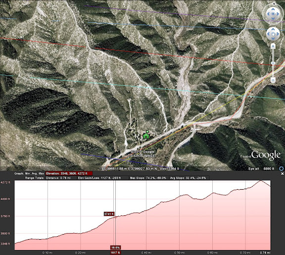
If you try to save the .kml file, the elevation data won't be included, so use of the elevation is inclusive only to viewing in Google Earth. Still, this addition combined with the topo overlay offers excellent options for route planning.
Subscribe to:
Posts (Atom)