Showing posts with label gps analysis. Show all posts

Friday, February 4, 2011

Optimal Hiking Grade - A 50 Hike GPS Analysis

Do you care about optimal hiking grade? Maybe not, but it's interesting for us to think about.

Intuitively, some may think that steeper trails should get you up higher more quickly because less energy is being put into the "horizontal miles" that a less steep trail would need.

However, we probably also feel that at some point something becomes too steep to ascend without the looseness of the terrain affecting our pace.

So what's the "optimal" grade? Well, I'm sure the answer is unique to an individual, but let's look at one person.

We previously did a little exploration into how Vertical Ascent Rate (VAR) varied with the steepness of a trail, but only with one example. Now I've combined 50 hikes worth of data.

The hikes:

  • Mostly in southern California (especially San Gabriels), some in Sierra and Bay Area
  • Diverse in conditions, includes much on trail and off trail
  • Some have brush
  • Varied terrain (loose, bouldering, etc...)
But it's a set of "real" hikes that I've done. A little Matlab coding and analysis, and we can see how often a given grade of terrain was hiked:




Wednesday, June 23, 2010

Editing GPX Files

Many GPS devices come with their own mapping / editing software that may or may not be sufficient for your own analysis. Personally, I use Matlab for much of my processing b/c I have a lot of control, but you'll also have to do a bit of programming.

First, if you want to convert your file from your specific file type to .gpx (or vice versa), I suggest using GPS Babel.

For some editing / analysis, you can use Excel. Open Excel then open the .gpx file. I would open it as "read only" or "xml-source" which seems to disable the macros. From here, you can plot / analysis the columns of data, including latitude, longitude, altitude, and time. However I don't think you'll be able to save it back as a .gpx file.

The easiest way is to download the free GPX Editor. Open up a .gpx file inside, and select the specific track segment you wish to edit. While I have not checked out all the options, I know you can double click on a row and edit the information inside. Make sure you hit the "check" box or it won't save the change.

Tuesday, June 22, 2010

Google Earth Mapping Discussion Update

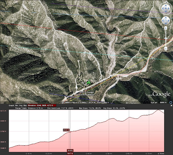
Earlier this year I outlined a way to overlay topographic maps in Google Earth, and subsequently get out path information to make maps and upload to your GPS device. The main downside with this method was that Google Earth did not provide elevation data when you created a path, so you would also have to use something like GPS Visualizer to get that information.

I was tipped off by Modern Hiker that the new version of Google Earth (5.2) is out and now it provides the elevation from its digital elevation model (DEM). Now when you create a path, you can right click on it's name in the sidebar and go to "Show Elevation Profile." Something like below should open up:


If you try to save the .kml file, the elevation data won't be included, so use of the elevation is inclusive only to viewing in Google Earth. Still, this addition combined with the topo overlay offers excellent options for route planning.

Friday, February 26, 2010

Vertical Ascent Rate

While we just looked at an example of how walking speed changes with change in trail steepness, it is also interesting to look at how vertical ascent rate (VAR) changes with trail steepness.


Of course, I think most people would generally hypothesize that VAR increases as the grade increases, since a larger % of energy will be spent on vertical movement. I would also hypothesize that above some grade (perhaps 60-70%), VAR would begin to decrease - I am thinking about loss of friction, change in terrain, and change in biomechanical efficiency - but that is simply conjecture at this point.


We will look at only one exemplar hike (Big Iron again) which is suitable because of the breadth of gradients encountered and I was attempting to hike at a constant pace. Below is a plot of VAR vs grade % (this time I multiplied by 100% so it makes more sense, like 15% grade on a treadmill).


Wednesday, February 24, 2010

How is Hiking Speed Affected by Steepness? A GPS Graphical Analysis

The short answer is we slow down as the trail gets steeper. Yes, I know, pretty obvious.

But how much? And what steepness / speeds are equivalent...is hiking a 10% grade fire road fast the same exertion as hiking up a 30 % grade mountain at 2 mph?

This is one of many things interesting to look at through the experimental data that a GPS device can collect. Take a look at the graph below, which shows my hiking speed versus the steepness of the trail while on a hike up Iron Mountain in the San Gabriels.